
Early Thoughts of the Intracoastal Waterway
The Point Pleasant area has documented history that dates back to 1609, which we take for granted for the most part. The planning of the Point Pleasant Canal, for example, had a significant strategic reason when first planned. Talk of the Intracoastal Waterway dates back to the Revolutionary War and the War of 1812. I’ve always considered the canal a waterway, giving boaters easier access to the ocean and Barnegat Bay. When I started to research the Canal further, I was pretty surprised.
Strategic and Defence
Shortly after the Revolutionary War, our newly formed government loosely started to plan the Intracoastal Waterway that would stretch from the Northern Atlantic Ocean to the Gulf of Mexico. This would create a safer route for traders to travel and avoid the rough Atlantic Ocean. During the War of 1812, The British formed a blockade of the east coast, which affected the military supply chain. This solidified the plans for the Intracoastal Waterway, and as a result, in 1826, congress authorized the survey to build a series of inland canals.
Fresh Water Eco System
It is a little-known fact that the Beaver Dam Creek, Metedconk River, and northern Barnegat Bay were fresh water before the canal. Can you imagine having fresh water in the Point Pleasant and Brick area? The Beaver Dam Creek, Mataloking River, and these bodies of water had a freshwater ecosystem. Some businesses depended on the freshwater, cranberry bogs, and the Icehouse in the Loveland section of Point Pleasant. But what happened? Where did it all go?
If our backbays were fresh water today, what would our lives be like? Just think of how many hockey players the area would’ve produced. Would we have fewer summers with water restrictions? Would our lawns be more accessible to keep green? I am not an expert in this area, but I hope to answer some questions that I now have.

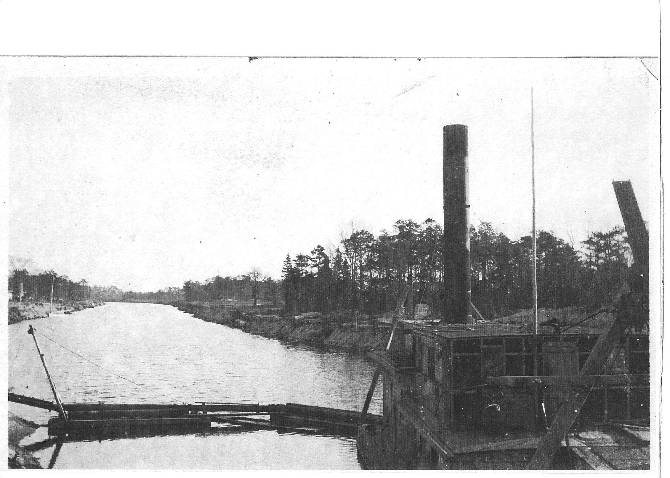
Construction of the Canal
In 1908, after almost 75 years of planning, New Jersey’s section of the Intracoastal waterway dredging had begun. Dredging started in the Cape May area and then in the Point Pleasant area. The Manasquan/Bay Head Canal was first authorized in 1833 by the New Jersey Assembly to connect the Manasquan River and the Barnegat Bay.
Dredging of the canal started in 1916, and only about a half mile in, construction stopped due to WWI. Dredging continued in 1918, but progress was plodding. When funding became an issue, different contractors took over from the last contractor, including the LeChard Dredging Company, which is still in business today.
Early Canal Route
There were many planned routes, with a 1903 plan that would bring the canal through Lake Louise, Little Silver Lake, Lake of the Lillies, and Twilight Lake Bay Head on its way to Barnegat Bay. In 1912, many deemed this route impractical for several reasons: its proximity to the beach, the requirement for eight bridges, including a railroad bridge, and the estimated cost of $155,000. The later plan, which was eventually adopted and built, at a much lower cost.
West Point Pleasant
The Point Pleasant Canal caused much controversy when it was first created in 1920. The canal separated the town of Brick from the newly created town of Point Pleasant. Even decades later, some still referred to the western side of the canal as West Point Pleasant. In 1964, the canal was renamed the Point Pleasant Canal from The Manasquan / Bay Head Canal. The canal’s construction started on the bayside towards the Manasquan River, and the freshwater there was untouched by the salt water of the River before the canal. Subsequently, there were many problems and negative feelings among the town’s residents. The debate revolved around whether constructing a canal would bring in tides, potentially destroying the freshwater ecosystem and businesses that depended on the freshwater.
Shoaling in the Inlet and the Canal
In 1931, authorities erected jetties to combat the continuous erosion and shoaling of the Manasquan River and the Inlet. However, there was also erosion and shoaling in the canal until 1935 they constructed wooden bulkheads. Unfortunately, by 1960, the bulkheads began to erode. The Army Corps of Engineers dropped boulders into the canal to limit erosion around the bridges. Unfortunately, this correction caused the water to become shallower, creating rapids through the Canal. By 1972 and these issues were addressed: the boulders were removed, the wooden bulkheads were replaced with steel, and both bridges were replaced, Bridge Ave in 1972, Route 88 in 1986.
Controversies
One of the first objections to the canal was the concern that the freshwater of the Barnegat Bay, Beaver Dam Creek, and the Metedeconk River would become salt water. The fishing would change; there would be no more pike, perch, or bass fishing. The cranberry bogs were at risk, and the Icehouse, where residents and fishermen stored their perishables, would close. There would be currents and tides to the calm water that would affect the area.
The canal was nearly closed six months after opening for a few reasons. The canal was constantly eroding from the current, causing shoaling and washing away the banks. The biggest issue was the diversion of the river, driving shoals in the Manasquan Inlet. The inlet was mainly closed until 1930, when it closed and reopened in February 1931.
There was the decision to correct the erosion by installing wooden bulkheads; that project would be completed in 1947. Boulders were dropped to support the aging bridges and repair the failing bulkheads, causing more shoaling and rougher currents and even rapids.
Conclusion
After researching the Point Pleasant Canal, I realized that the benefits outweigh the negative, this caused many problems, and maybe the canal construction could have been better. After all that planning, building, and money, it took over 40 years to get the canal to flow correctly.
I had often thought about how Point Pleasant would be without the canal. How would the streets connect? How much easier would it be for locals to get to the beach? This would seriously affect the Point Pleasant community and homebuyers looking for waterfront homes. Do you want access to the Barnegat Bay or the Manasquan River without easy access to the other?
What do you think?
Was the canal worth destroying a freshwater ecosystem and causing so many problems over the years?
The Point Pleasant Canal has become an integral part of this area, but how would Point Pleasant be different without it? Would the absence of the canal be beneficial, or would it have a negative effect? What do you think?
If you live on the water in Point Pleasant or Brick, If the canal wasn’t there, and you are looking to live on the water, Would you live on the river with access to the Ocean or on the bayside with 1 1/2 hours to the ocean?
Where would you launch or dock your boat if you were a boater? The riverside with quick access to the ocean, or the bayside with freshwater and an hour and a half to the ocean?
I want your feedback on this blog. Please leave a comment.
Recent Posts
Navigating Probate: A Compassionate Guide for Those Grieving
Introduction In the wake of losing a loved one, grief can be overwhelming. Amidst the emotional turmoil, managing the complexities of probate can feel like an insurmountable challenge. Probate is...
Unlock Up to $22,000 in NJ First-Time Homebuyer Grants! Are you thinking about your first home but worried about affordability? Discover the NJ First-Time Homebuyer Grant, offering up to $22,000...